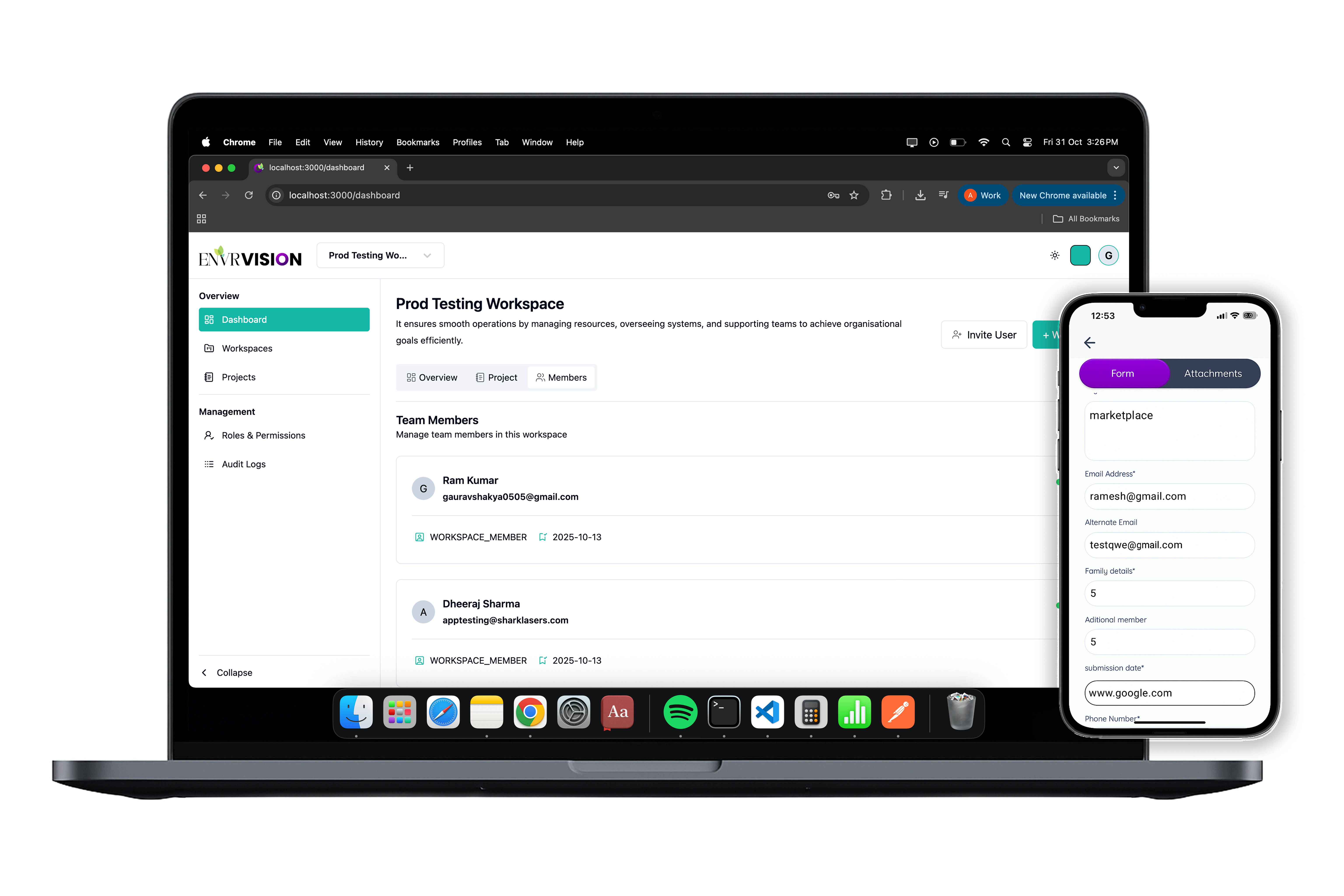
Why dMRV Acts as a Deterrent in Carbon Markets
Explore how Digital Monitoring, Reporting, and Verification systems serve as powerful deterrents against fraud and manipulation.
Every year, millions of hectares of forests, grasslands, and wetlands change — often silently. Data about these landscapes exists, but it's fragmented, outdated, or locked in spreadsheets. Verification becomes slow, expensive, and disconnected from the ground.
EnvrVision was built to change that.
We believe that credible climate action starts with clarity — and clarity begins with data you can trust.
Start MonitoringThat's why we designed EnvrVision as a living map of environmental truth — where every project, every task, and every datapoint reflects what's actually happening on the ground, in real time.
From a field officer walking through a forest in Meghalaya to a GIS analyst monitoring satellite change in Brazil — EnvrVision connects every layer of environmental work into one seamless system.
It's more than software. It's a movement towards measurable, transparent, and verifiable impact — a world where we can not only measure change, but understand it deeply.
The global carbon market is evolving fast. But while carbon projects are expanding, verification still struggles to keep pace.
EnvrVision bridges that gap.
By combining GIS intelligence, on-ground data collection, and automated verification, we're building a new digital standard for trust in carbon projects.
Our system captures complexity — from the geometry of polygons to the reality of field photos — and turns it into evidence that withstands audit, analysis, and time.
Because impact, when measured right, inspires action.
At its core, EnvrVision is powered by satellite data, dynamic forms, and AI-assisted analytics — but it's built for people: for field teams, project developers, auditors, and communities.
Our technology doesn't replace human insight — it amplifies it.
It makes monitoring effortless, data meaningful, and verification honest.
And because every project deserves a system as resilient as the ecosystems it protects, we designed EnvrVision to scale — across countries, climates, and carbon methodologies.
We started EnvrVision with a simple question:
How can we make environmental verification as clear and intuitive as the ecosystems we're trying to protect?
Our answer is a platform that sees landscapes not as static maps — but as dynamic, evolving systems.
Where every field input, every GIS layer, and every satellite image contributes to a living record of impact.
This is how the future of environmental data should look — connected, verifiable, and alive.
Technology can map the earth. But it's people who protect it.
From local communities and field workers to scientists and project developers — EnvrVision was built to empower everyone contributing to real climate action.
Every form filled, every polygon drawn, and every photo uploaded represents a collective effort to understand our planet better.
Because when data becomes human, it drives change that lasts.
transparent, grounded, and geospatial at its core.
EnvrVision fuses live satellite intelligence with workflow automation and audit-ready records, so every stakeholder works from the same source of truth.
Real-time satellite analysis with field truth integration for comprehensive environmental monitoring.
Continuous observation with AI-powered change detection and instant alerts
Secured data with automated reporting and complete audit trails
Mobile data collection with automatic sync and real-time collaboration
Discover the latest in climate monitoring, satellite technology, and environmental insights
Explore how Digital Monitoring, Reporting, and Verification systems serve as powerful deterrents against fraud and manipulation.
A comprehensive research report on AI applications in climate modeling, renewable energy, carbon capture, and environmental monitoring systems.
Learn how continuous satellite monitoring is enabling more accurate and transparent carbon credit verification processes.
Share a little about your project and we’ll reach out with the next steps.